
 |
| A: Kill Devil Hill, B: Waves, C: Hatteras Landing, D: Cedar Island |
Rich with history, the Outer Banks is where the first known person of English decent was born on American soil in the English Roanoke Colony on Roanoke Island. The colony mysteriously vanished and no trace has ever been found of “The Lost Colony.” The Graveyard of the Atlantic, part of the Atlantic Ocean along the Outer Banks, is aptly named owing to numerous shipwrecks that litter the ocean floor. The Wright Brothers first powered flight took place on the Outer Banks in 1903. “Banker Ponies”, a herd of feral horses which local legend claims to be descendants of Spanish Mustangs still inhabit parts of Ocracoke Island. Ocracoke Island was also the home base for the feared pirate, Edward Teach (more popularly known as Blackbeard) and is where the pirate eventually met his end.
Our route from Suffolk took us south on Hwy 158 to the Wright Memorial Bridge where we officially crossed onto Bodie Island. The northern most portion of the Outer Banks are found south of Norfork, VA, but for our purposes, this would be the northern most portion of the Outer Banks we would encounter. Having a bridge to cross wasn't always an option. Up until the 1930’s, all access to the Outer Banks was strictly by boat. And even now, the only way to leave the southern end of the Outer Banks and return to the mainland, is by boat.
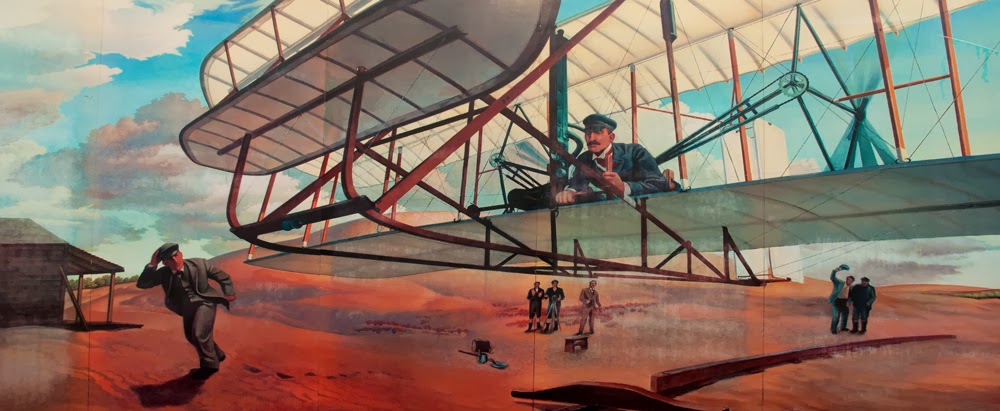
Our base of operations for the week would be Ocean Waves Campground located in the small unincorporated community of Waves on Hatteras Island. But since we were already so close to Kill Devil Hill, site of the Wright Brothers National Memorial, and with plenty of time before we had to be in Waves, we opted to stop.


 |
| Wright Brothers National Memorial |
The national memorial has an extensive interpretive center and gift shop, offers regular tours and lectures, and an opportunity to cover the very ground where the first four historic flights occurred. While we were able to find a parking space to accommodate our truck and RV, it would have been nice if other visitors had not hogged RV designated spots to park their much smaller passenger cars (a pet peeve of ours that occurs in many parks).

 |
| wind surfing |


 |
| Ocean Waves CG, across the dune, wide open beach |
 |
| site at Ocean Waves CG |

 |
| Cape Hatteras - new site and looking back from the former site |
 |
| view from the doorway |
After years of debate, in 1999 it was determined that due to significant erosion of the immediate coastline which was endangering the lighthouse, that the lighthouse be relocated 2,900 feet from the spot it had occupied since 1870. The once 1,500 foot buffer from the ocean had all but virtually disappeared. It took a mere 23 days to complete the move although it took much longer to prepare. A very impressive engineering feat to say the least!
 |
| Cape Hatteras Landing |
Typically Brian doesn’t run pelagic trips every September but this year he had two trips scheduled on a weekend when we would be in the area. The weather still looked pretty iffy for the weekend, and from what Brian said, the chances for a Saturday trip were pretty slim. But as far as Sunday’s trip was concerned, he would call us late Saturday to confirm if it was a go or not.


 |
| sandy Hwy 158, Pea Island trail, Pea Island impoundment |
Midway on the Atlantic Flyway, Pea Island NWR is used by numerous migrating waterfowl, shorebirds, and raptors, as well as wintering wading birds. The refuge derives its name from “dune peas”, a small plant with pink flowers that provides a predictable food source for a Greater Snow Goose population that winters on the Outer Banks.
The refuge lies on the northern edge of the nesting range for the Loggerhead Sea Turtle. Although relatively few turtles actually nest on the refuge, the location, with its cooler average temperatures, is still important because the sex of a turtle is determined by the temperature at which the eggs are incubated. Cooler temperatures produce more males. As a result, most of the males for the entire Loggerhead Sea Turtle population are produced here.
At the refuge’s visitor center, we met a young couple who had, like us, gone full time. However, in their case, they had both given up their jobs to do so and depended far more on getting volunteer positions. It’s interesting how we are running more and more into couples that have given up their jobs to pursue a life on the road, albeit, still working out of their RV whenever possible.
Birding at the refuge turned out to be very slow owing to high winds as we hiked a few of the trails from the visitor center so we drove a bit further up the road to another lighthouse, the Bodie Island Light Station, another impressive “Guardian of the Sea”. The distinctive black-and-white banding paint job on this lighthouse was hard to miss. And with most other lighthouses we have visited, the present lighthouse had been preceded by earlier lighthouses on the same site.


 |
| Bodie Island Light Station |
Rather than continue to be battered by the wind we headed back to the RV to keep and eye on the weather and await word from Brain Patteson about Sunday’s pelagic trip.
Around 8:00 that evening, Brian phoned to say that the trip was a go! Yay! It was still going to be windy but doable. We gathered up our wet weather gear, packed some food, and retired early. Finally, after several disappointments through the summer, we were going to get out for some pelagic birding on the east coast.
The Hatteras Landing Marina was a good hour’s drive away so in order to make our 6:00 a.m. dockside arrival we departed at 4:45. Traffic was predictably light as we drove the entire distance in the dark. There were stars in the sky, and while it was still windy, it felt as though the wind had abated somewhat. We were hopeful.
 |
| Stormy Petrel II |
Where would we be most likely to find a petrel? In the Gulf Stream. Beginning in the Caribbean and ending in the North Atlantic, the Gulf Stream current plays an important role in the poleward transfer of heat and salt and serves to impact weather patterns from the U.S. to the European subcontinent. The position of the Gulf Stream, it’s relative distance from the U.S. shoreline, changes throughout the year. For our purposes today, the Gulf Stream was 27 miles offshore. And with its rich nutrients attracting pelagic birds, it was where we needed to be in order to maximize our chances for finding as many pelagic bird species as possible.
 |
| Ryan and Carol from our early days at Tandayapa Lodge |
 |
| Bottlenose Dolphins |
As we pitched and rolled, alternating between feeling like a cork or a pinball, we thought about the length of the boat. At 61’ it was just half the distance the Wright Brothers had traveled on their first flight. But at no time did we ever feel the need “for a bigger boat”.
Eventually we reached the Gulf Stream. The color of this river within an ocean changed to a deeper hue of blue. Another identifying feature was a greater abundance of free-floating seaweed of the genus Sargassum, a ‘holopelagic’ seaweed species that reproduces on the high seas. Sargassum supports a variety of marine life including sea turtles that use the mats as nurseries where hatchlings have food and shelter. Commercial fish like bluefin tuna and Atlantic salmon migrate through Sargassum, depending on it for food. And pelagic birds spend most of their adult life feeding on other marine life attracted to these free-floating mats.
Once well out into open water the boat's crew starting chumming, a method of attracting seabirds by leaving a scent trail comprised of fish oil and food items (dead fish parts). In this case frozen blocks of fish parts were put into a mesh bag and let out on a rope behind the boat. Not only does chum attract seabirds but it usually brings the birds in quite close for better viewing.
By the time we reached the Gulf Stream, we found the wind to be blowing against the Gulf Stream’s current producing waves that literally stood up on end. It was all we could to balance ourselves, with binoculars in hand, trying to avoid salt spray, while snatching glimpses of birds as they were called out. Pretty heady birding to say the least!
But our efforts paid off. We managed to add four life birds. And when it was all over and done, we got some pretty good looks at them. Cory’s Shearwater, Audubon’s Shearwater, Wilson’s Storm-Petrel and a high light for everyone, several Black-capped Petrel.
 |
| happy to be back in port 11 hours later |
You can read Brian’s report of our trip along with viewing accompanying photos here. Interesting looking at the photos - the water looked so calm!
Completely drained of energy, and starving (eating on a pitching boat didn’t seem like a good idea), we stopped for a bite at a local sub sandwich and pizza joint before heading back to RV which we reached as we had left - in the dark.
 |
| any birder would know what's missing! |
The shutdown’s immediate impact on Tuesday was evident as we traveled to Nags Head to visit the North Carolina Aquarium on Roanoke Island. Several beach access points to Cape Hatteras National Seashore were barricaded. Pea Island National Wildlife Refuge was closed; yellow tape blocking the trail heads. A reply to an email to the volunteer couple we had met said that they were faring well. For the time being they were being allowed to stay parked on the property with their RV, but that they were forbidden, along with the general public, from using the refuge. Knowing that we too were going to be volunteering at a NWR beginning in November, we were concerned as well. However, there was little we could do at present. We were grateful that we had managed to visit most of the parks and memorials because they were now all shuttered. But we felt badly for all the Federal employees who had been furloughed as well as area businesses that would see a drop in tourism dollars.


 |
| aquarium inhabitants |
Our last full day on the Outer Banks was spent walking the beach, boxing up Tom’s binoculars to send to Nikon, mailing them from the Avon Post Office, and stopping for dinner in Avon at the Open Water Grill.
Carol had been looking at various local restaurant menus online. With what she found, plus acting on the advice of locals, we stopped at the Open Water Grill late in the afternoon. We were seated immediately and selected a local brew from their beer list. Initially disappointed because the menu online was not available (a seasonal change had just occurred), Martin, the owner, offered us a meal at a price we couldn’t refuse: Mahi-Mahi, served with Israeli Couscous. The Couscous was cooked with a wonderful combination of cheeses, cream and butter. Absolutely delicious. And Martin had just returned from the market with fresh summer squash which he sautéed to perfection. The view was lovely and the staff extremely accommodating. If you find yourself on the Outer Banks in the town of Avon, check out the Open Water Grill…and be sure to mention to Martin you heard about his place from us.
Unsure of how long the shutdown would last, and realizing we would likely feel more affects as we headed further south to Florida, of immediate concern was our reservation for an overnight in the Croatan National Forest on the mainland. It had been cancelled which left us scrambling (along with many other travelers to be sure) for an alternative site further down the coast. We usually rebound pretty quickly with a plan B and this was no exception. However, due to our having to take two ferries the next day (one needing a reservation) to reach the mainland, our travel day, while short on miles, would be long in hours.

 |
| Hatteras to Ocracoke |

 |
| Ocracoke to Cedar Island ferry |

To give us a safe buffer of time we packed up and left Waves by 8:00 a.m.. Fortunately there were no traffic holdups and we managed to make both ferry trips on time. The latter trip from Ocracoke to Cedar Island wound up taking a half hour longer due to the ferry having to make a wide berth around some dredging operations. However, the trip felt much shorter as we chatted most of the way with a couple on a BMW motorcycle headed for Florida pulling a small trailer with their faithful dog perched on top. They were on the return side of a trip to the Arctic Circle. And we thought WE had been doing some traveling! We pulled out a folding chair, sat on the deck, and heard all about their adventures.

 |
| chatting with the Arctic Circle travelers |


Nice pics Tom .. Loved the surfer & the turtles the best. I was looking for the name of the place you stayed by Charleston & Savannah though .. no post on that yet??
ReplyDelete